In recent years, there has been a global push to expand marine conservation efforts, but the quality of the implemented conservation network has often been neglected in favor of quantity. In a new paper published in Nature Communications, Juliette Jacquemont tackles one of the limitations of marine spatial planning by conducting the first global assessment of the 3D distribution of fishing activities and conservation coverage. As with many other marine features, such as species distribution, this information has until now only been assessed in two-dimensions, overlooking the vertical dimension inherent to the ocean, which reaches an average depth of 3,800 m. This simplistic representation of the ocean has remained unchallenged in part because until recently, most human activities and impacts were limited to coastal and shallow areas where the vertical dimension is more limited.

This representation shift is particularly important given the current context of marine conservation. With the ratification of the United Nations (UN) Convention on Biological Diversity (CBD)’s Kunming-Montreal Global Biodiversity Framework (GBF), a commitment to protect 30% of Earth’s oceans, coastal areas and inland waters by 2030, and the ‘High Seas’ treaty, which now provides legal instruments to implement marine protected areas in the High Seas, an increasing amount of protection coverage will be targeting deep, vertically complex areas. The High Seas are areas beyond national boundaries, covering two thirds of the planet’s oceans, and where much of the deepest zones of the ocean are found. These advances in marine conservation are paralleled with increasing human activities targeting deep marine ecosystems, with fisheries pursuing deeper stocks as shallow ones deplete, and prospects for deep-sea mining multiply.
Hoping to better inform the next wave of conservation, Juliette’s PhD work at SAFS aims to augment existing 2D spatial planning tools of the ocean by adding a third dimension: depth. How are ecosystems at different depths captured by global conservation efforts, and how does this contrast with the depth distribution of fishing activities? These were a couple of the questions driving Juliette’s work with her co-authors, including her advisor, SAFS Professor Luke Tornabene.
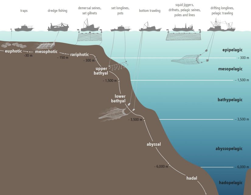
Using a global fisheries dataset (the Global Fishing Watch), which captures 60% of all large-scale, industrial fishing effort in the world, Juliette overlaid spatial information on fishing activities, gear types, and ocean bathymetry maps (which provide the depth of ocean floors). This allowed her to identify the depth at which fisheries are occurring, in comparison to the depth covered by marine protected areas, which she obtained using the World Database on Protected Areas.
What she discovered was an uneven distribution of conservation coverage across depths, with the shallowest ecosystems, down to 30 m, receiving the most protection. In contrast, mesophotic (60-300 m) and abyssal (3500-6000 m) depths were woefully behind global conservation targets, a result of being “out of sight, out of mind”, but also because of the lack of legal instruments to implement conservation beyond national jurisdictions. Furthermore, Juliette found that a surprising large proportion (over a third) of fishing activities occurred in deep-sea (deeper than 300 m) areas. Additionally, an important part of epipelagic and mesopelagic fishing occurs in areas overlying abyssal depths, which might be impacting the fragile abyssal benthic communities which depend on pelagic biomass.
Another concerning result from Juliette’s work is that many of the areas that have received the most conservation effort correspond to areas where the least fishing occurs, a phenomenon called “residual conservation”. Residual conservation is often motivated by ease of implementation, as no interference with human activities arises from the newly implemented conservation unit. However, the ecological additionality of these conservation actions is limited, as these areas were already protected ‘de facto’. This common mechanism has led to the incidental representation of some deep marine ecosystems at the limits of territorial waters, which are usually under less human uses than shallow, coastal ones. Unfortunately, the associated levels of protection of these areas are often weak, providing little protection from potential future uses.
While the remoteness of deep ocean ecosystems has also resulted in them not being very well-described by science, the development of new surveying tools, for example rebreather diving and remotely operated vehicles, is unveiling a staggering amount of diversity, often extremely sensitive to extractive activities because of slow growth and low productivity. As such, deep ecosystems appear as priority areas to actively conserve and avoid irreversible impacts from “boom and bust” fisheries and multiplying mining prospects.

Many things aligned at the same time as Juliette began her research in this area. She always had an interest in global conservation targets and in weaknesses limiting the efficiency of the global conservation network. Being a member of the Fish Systematics and Biodiversity Lab at SAFS, which has a focus on deeper ecosystems, solidified the idea of looking at representation across the depth dimension. With the High Seas treaty and the updated Global Biodiversity Framework being ratified while working on her paper, it makes her findings even more relevant as nations will have to expand their conservation network to cover 30% of their territorial waters, requiring the inclusion of deep-sea areas.
This study revealed important knowledge and management gaps that Juliette intends to investigate in future research. In particular, the lack of information on the depths targeted by fishing gear types and targeted species, and the absence of discrimination between pelagic and benthic activities in the Global Fishing Watch dataset, constitute major limitations in understanding the 3D footprint of fisheries and the 3D space they impact. In parallel, developing follow-up studies at the regional scale would better account for small-scale fisheries (commonly under-represented in global datasets), local fishing practices, specificities of area-based management plans, and of ecosystem distribution. This, in turn, would provide actionable recommendations at the regional scale for policy- and decision-makers to account for the vertical stratification of marine life and human uses, as well as the multiple connectivity processes through which impacts might trickle between pelagic and benthic systems. While working on this area of study, Juliette is also participating in research efforts to better describe understudied and under-protected marine ecosystems, such as mesophotic reefs.