Leave the imported shrimp, take the local bivalves: sustainable seafood choices
From the classroom to the coastline: spotlighting UW’s School of Aquatic and Fishery Science
Ecologists: don’t lose touch with the joy of fieldwork
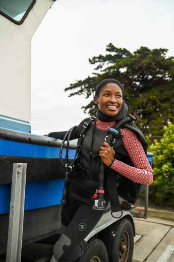
Diving into aquatic science: Open House returns on May 18
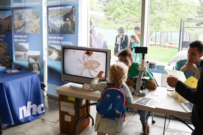
Bringing aquatic science to life for the people of Seattle for the sixth time, the UW Aquatic Sciences Open House returns for a free, family-friendly day of fun on Saturday 18 May. Open to everyone – from toddlers to teenagers to adults – we’re showcasing the amazing breadth of wet sciences at the University of Washington.
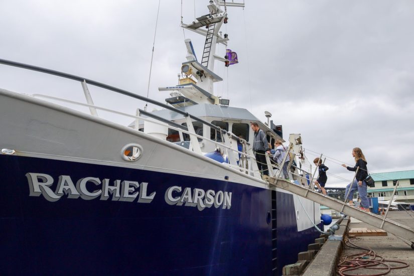
Kicking off at 10am, we’ve got fan favorites like exploring the live aquarium tanks which are home starfish, telling the difference between native versus invasive crabs, and peering through microscopes to see tiny marine organisms. The research vessel Rachel Carson, which conducts oceanography research along the PNW coast, begin their tours at 12pm. Brand new this year will be a special face painting booth. We’ve also got some new research on show, including viewing microscopic parasites and seeing how drones are used in science. Visit our Open House page for a full list of booths at this year’s event.
In Seattle, we’re surrounded by water – from rivers and lakes to the Puget Sound. It’s important that this event, which brings together marine and freshwater scientists from across the University of Washington, is made open and accessible for the public to get involved with the science and research that surrounds us. We are happy to be able to offer in-person, on-the-day interpretation in both Spanish and ASL, made possible by the sponsorship of foundry10.
“We are thrilled to support the UW Aquatic Sciences Open House, an exciting event that educates and inspires youth to dive in and discover the wonders of our local marine ecosystems alongside knowledgeable researchers and educators,” said foundry10 Co-Founder and CEO Lisa Castaneda.
Want to stay up to date with all the exciting things taking place this year? Join our Facebook event to stay tuned as we release more details in the lead-up to the Aquatic Sciences Open House!
Global rankings place UW Earth and Marine Sciences programs at no. 10
What four decades of canned salmon reveal about marine food webs
Combining ecology with spatial data: New book delivers toolbox for ecologists
In a new book providing a guided walkthrough and toolbox to conduct population and ecosystem modeling at high-spatial resolution, James Thorson (SAFS alum and affiliate faculty, and Statistical Ecologist at NOAA) has co-authored Spatio-Temporal Models for Ecologists with Kasper Kristensen. Coming up with the idea for the book during a meeting at SAFS almost a decade ago, we sat down with James to find out more about why it’s a useful tool for ecologists.
Tell us what was the impetus behind writing a book on this topic, and what new insights into ecology it provides?
Most efforts to determine whether ecosystems are managed sustainably in ecology and fisheries have tracked total abundance for specific populations, species, or communities. But the increased challenges presented by climate and its impact on spatial management means we need to transition from concepts of ecology measuring population abundance, to instead use fine-scale spatial information on population densities in different habitats.
Why is this work important? Because much of our policy is written to achieve sustainability for an entire population. These are blunt indicators for questions such as: are we catching too many fish, do we have too few wetlands, have we paved too many meadows for bees? However, these indicators then bring us to the solutions side. Problems are global, solutions are local. For most people, issues like changing sea ice in the Arctic are more impactful when they understand how it affects their local community. Ecology shouldn’t just be highlighting big trends, but also direct us to local solutions. Spatial analysis allow us to identify both local and regional solutions to issues of sustainability.
So, the book is intended to be a guided walkthrough using a minimal set of tools for people working in applied ecology that can be used to implement a wide range of real-world ecological problems. We use varied examples including fish species from Alaska, birds from the western United States, movement models of northern fur seals, and ozone concentrations on the east coast. For example, one example used a technique called “Empirical Orthogonal Functions” to show that declining summer sea ice in the Arctic could be explained by two dominant patterns, including a decrease in sea ice near Russia around 2005, and a separate pattern of decreasing sea ice in the Pacific gateway (north of Alaska) in 2007 and again in 2012 (Fig. 1). These high-level patterns aren’t so obvious when just looking at annual sea ice patterns (Fig. 2), and simplifying the patterns then moves the conversation forward by emphasizing different local impacts of a global pattern.
-
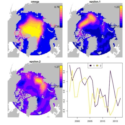
- Empirical orthogonal function model components that explain summertime Arctic sea ice concentrations, including the average spatial component (top-left panel), the spatial response for both models (top-right and bottom-left), and the temporal index associated with each mode (bottom-right).

-

- Predicted concentration of sea ice in September from 1997 to 2017 fitted using a spatio-temporal index model, based on satellite measurements and restricted to locations within 3000 km of the north pole.

Who did you write this book for?
There are plenty of textbooks on statistical theory written for graduate students in statistics, and others which focus on basic analyses using free software like R. However, for ecologists, we find that the former may be too complicated, and the latter can only implement a relatively small set of canned analyses. What our book aims for is the middle ground, where people can build custom tools using minimal code – snippets that people can snap together like Legos – and build exactly what they want out of a spatial model for their ecological questions. Custom-built tools such as these then allow ecologists to address the specific context and questions that local stakeholders care about. These custom-build models are widely used in managing fish, birds, and mammals, where they’re called stock assessments or integrated population models. In some sense, the book aims to do the same thing for spatial statistics, so ecologists can combine their ecological expertise with spatial data.
In every fisheries science lab across the country, there are numerous people working in specialized spatial analysis. I think that this book will be an essential tool for their work. It’s also useful for all realms of study – terrestrial and aquatic species, mobile animals and plants growing in fixed locations. And that’s because we’re presenting the math and then breaking it down into computer steps and code, all hosted in a GitHub repository, that people can reuse. For example, we show how to combine data from three different sampling programs, which measure presence/absence, numbers, and biomass of red snapper in different portions of the Gulf of Mexico (Fig. 3). Existing software packages aren’t available to deal with a complicated setting like this, but it’s straightforward when you can customize the model using high-level code. Spatial statistics isn’t something which most ecologists learn, but it’s very useful and widely applicable in fisheries science and ecology.

Share with us some of the things in your book that will be useful for ecologists?
I’ve always loved how ecosystems change across landscapes and have been very interested in how spatial patterns change with climate change. Spatial information is extremely important when asking and answering questions around conservation science and resource management. But these fields usually use stock assessment models and integrated population models to take a bunch of data and make it into policy-relevant information. I think our toolbox should be co-equal with that effort, by assisting with spatial knowledge on how to help humans do their activities sustainably in different parts of the landscape. This is the first book to show how we can conduct this custom-built spatial analysis that’s driven by questions versus what software is available and accessible.
My co-author, Kasper Kristensen, build the Template Model Builder (TMB) software which is reused in many different applications. A big chunk of this book is laying out how to use their powerful piece of software in an understandable way. The first two chapters in particular are a guided introduction to TMB. Another useful part of the book is that it uses entirely open source, free-to-use software such as R, and computational heavy work with TMB. This addresses part of the need for this book, which is that many ecologists use accessible software like R, versus tools only existing behind paywalls.
What was the process like for you, writing a book?
One of the special things we’ve found about writing a book is we can take a decade of work and amalgamate it in one book – this isn’t always possible in research papers which have to be a lot shorter, each emphasizing some novel advance in isolation. With this book, which was a really fun and rewarding process to brainstorm and write over the last decade, we have a lot more discretion in telling the whole story around our topic. This book brings together lots of terminology and software and condenses it into a minimal set of principles and numerical techniques for ecologists in different fields. Our previous developments have been scattered across over 100 papers in a wide range of journals, and it can take years for new students or researchers to put the story together. We hope that our book provides a fun and gentle introduction to both the statistics and ecology involved in finding local solutions for global environmental problems.

Carey Kuhn, MMPA Permit No. 14327
Letting nature be nature: restoring Puget Sound’s shoreline
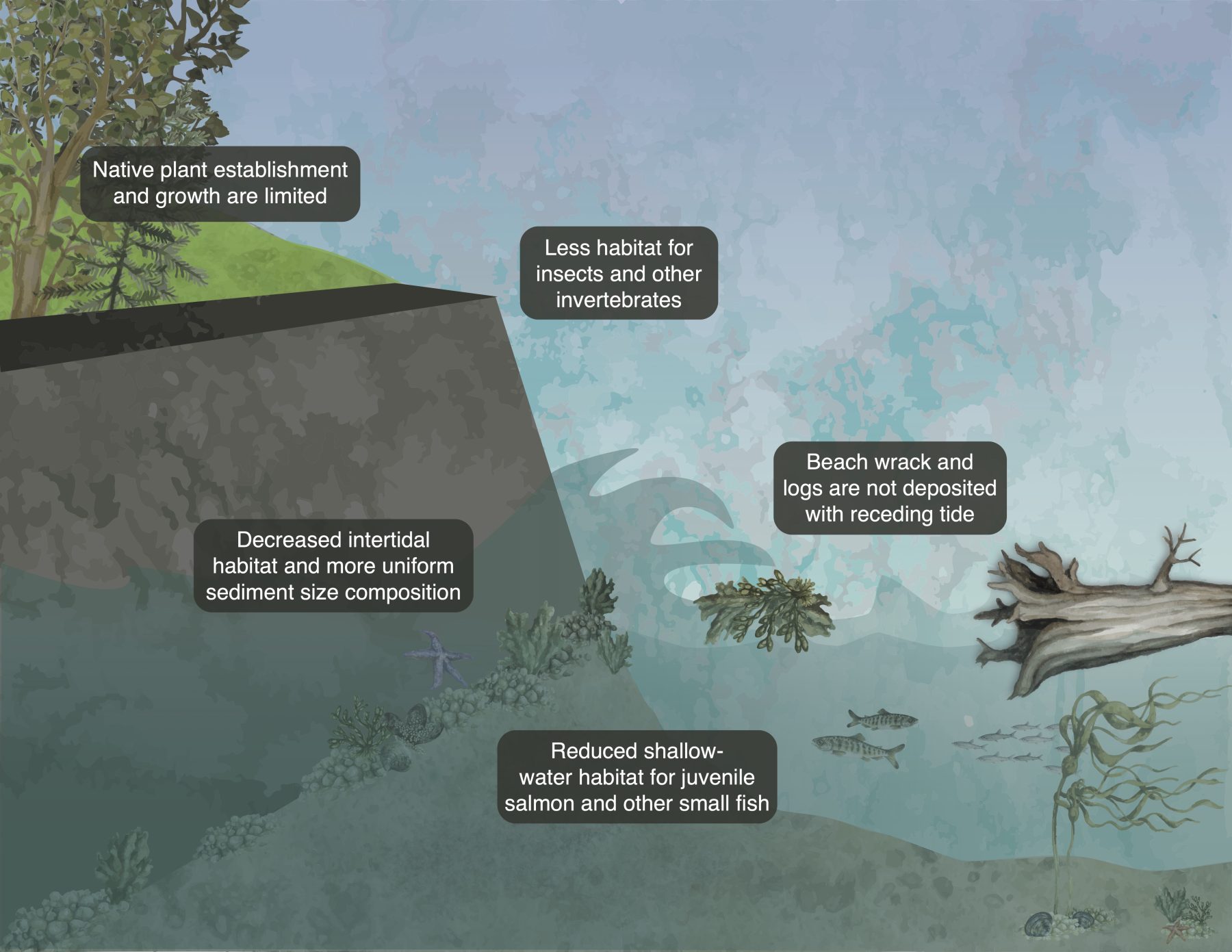
Stretching from Admiralty Inlet to the city of Olympia, Puget Sound has 1330 miles of shoreline. Home to 4 million people along its shores, armor covers over 25% of the region’s shoreline. In the summer of 2023, we caught up with University of Washington School of Aquatic and Fisheries Sciences (UW SAFS) researcher, Jason Toft from the Wetland Ecosystem Team, who has been working for over 10 years on monitoring the impact of shoreline restoration when armor is removed. Installed throughout the last century to minimize erosion risk in the uplands, science has actually revealed the opposite is the case waterward of the armor: armor disrupts the natural ecosystem of shorelines that support habitat for much of Puget Sound’s fish, wildlife and vegetation.
In a new paper published in Restoration Ecology, Simone Des Roches, a UW SAFS Research Scientist, led a team of researchers studying the impact of armor removal and other restoration activities on shorelines through time in Puget Sound locations. “Part of the issue with evaluating the most effective shoreline restoration strategy is that it’s very hard to pinpoint only one thing, as the actions are so interactive,” shared Simone. “In general, other restoration activities such as planting native vegetation and log placement aren’t as effective without armor removal, so that remains the most important shoreline restoration strategy to start with. Everything else follows from there.”
Simone Des Roches
With armor removal gaining momentum in the last decade, almost 30 restoration sites monitored by the Wetland Ecosystem Team in collaboration with their partners are covered in the new publication. “A major impetus for the removal of shoreline armor was the Puget Sound Chinook salmon being listed as threatened under the Endangered Species Act in 1999,” Jason shared. “This led to subsequent exploration of the impacts of armor on shorelines in the region.”
Once armor is removed, planting endemic, native vegetation, such as dunegrass, is one of the most important ‘living shoreline’ strategies. “When armor is initially removed, you inevitably get some erosion as the natural processes come back into play. By planting things like dunegrass that grow and establish quickly and has a lot of fine root systems that retain sediment, this is a great way to reduce a massive amount of erosion,” Simone noted. “It also has a higher chance of success as it occurs naturally in our Puget Sound region. By planting it in restoration projects, we give this flora a head-start on invasive species such as blackberry bushes. In essence, we’re kickstarting the natural endemic function before invasive ones have a chance to establish.”
So, what is considered a successful restoration of a shoreline? “The answer isn’t so simple,” said Simone. “Along with initial erosion, the removal of armor along a shoreline can make a previously tidy shoreline look, quite frankly, messy. But this is because restoring ecosystems is a process, and natural systems are dynamic. Restoration is not a one and done activity.” In many cases, scientists might not know what a successful restoration project looks like for many years as natural processes take time to adjust to armor removal.

Simone Des Roches
The added effects of climate change also have unprecedented consequences that are still being studied, and so the removal of armor might not result in a shoreline looking the same as it did pre-armor. “One of the key things we deal with in our new paper is that shoreline restoration is happening at different timescales and therefore it’s difficult to look at these projects and make definitive judgements on what success looks like,” Simone noted. “Armor removal hasn’t happened on every Puget Sound shoreline on one day. And the timescales we’re looking at – spanning 10s of years – are still undergoing transitions that may even outlive us.”
A vital part of armor removal and shoreline restoration projects is public education and participation in restoration projects. “The Shoreline Monitoring Database has been essential for combining data from multiple groups, including community scientists,” Jason said. A collaborative project developed by a team including community science groups, the Washington Department of Fish and Wildlife (WDFW) and UW, the Shoreline Monitoring Database provides publicly accessible, standardized protocols to allow for widespread shoreline monitoring and training.
“There are a lot of nuances in restoration, and I would love to emphasize, especially to the public, that natural systems are messy and variable,” Simone added. “One of the things that shoreline armor and river dams are doing is constraining natural processes so there is less variability. By removing this, we end up with a wild, messy, natural system, which looking at in comparison to a neat and tidy beach, can be quite uncomfortable for many people. But I like to say: trust the process!”

Niamh Owen-McLaughlin
A huge amount of diversity exists in the types of shorelines found in Puget Sound, from pebbly beaches and sandy beaches, to sheer cliffs and rockpools. “This means there is no one ideal shoreline to aim for in restoration projects,” said Simone. “The many types of beaches depend on where the water is flowing from, how far it flows, what direction the beach is facing, how much sediment comes in. But all these characteristics contribute to a functioning shoreline ecosystem. Because of this, the ideal functioning shoreline looks messy, with lots of logs and vegetation, the presence of beach wrack, and different types of bugs living in the washed-up seaweed and in the sand. And all of this contributes to the presence of other species such as birds, fish, and even whales that the ecosystem is supporting.”
This brings us to an important question – how far into the water does an effective, functioning, restored shoreline stretch? The answer is quite far. “The farther down the shoreline you build armor, the more naturally sloping beach you’re removing. This is an important shallow habitat and safety zone for small fishes and other marine organisms that are significant food sources for bigger species that don’t go into shallow water, such as orcas,” Simone noted. “So, shoreline restoration doesn’t just impact the small bit of visible coastline that we can see, but instead has huge implications for the entire ecosystem that makes up Puget Sound.”
“My ultimate takeaway for people interested in shoreline restoration is to embrace the disorderly – that’s what nature is,” Simone shared. “Letting nature be nature is something we should be applying not just to our shorelines, but also to our rivers and other spaces. It means we should look to creative solutions for our living spaces to be in synergy with nature, and part of this is accepting that these spaces might not be neat, tidy, predictable, and homogenous.”
An ambassador for diversity in marine science: a conversation with Xochitl Clare
Recently contributing to a special Oceanography issue titled ‘Building Diversity, Equity, and Inclusion in the Ocean Sciences’ was Dr. Xochitl Clare, a postdoctoral scholar at SAFS. We caught up with Xochitl about her journey to becoming a marine biologist, her background in Film and Theatre, and what inspires her to be a mentor working towards diversity, equity and inclusion (DEI). In the special issue, Xochitl contributed her own autobiography about her identity as a first-generation Afro-Latina Marine Biologist and Performing Artist, and co-authored a paper on an initiative to support inclusive mentoring practices. Xochitl is a member of the Padilla-Gamiño Lab at SAFS and is conducting her research on sea cucumbers in the Pacific Northwest and Belize, an important bio-indicator species for marine ecosystems. Her work is supported by the Washington Research Foundation.
Tell us some more about the importance of being involved in the special Oceanography issue looking into inclusion in ocean science?
The first thing that comes to mind when I think about that paper, is that I represent a lot of identities and peoples. I’m from a first-generation immigrant family – my mother is from Jamaica and my father is from Belize. I’m the first in my family to pursue higher education in marine science and embark on ocean exploration.
I never had access to the ocean growing up as a child in Glendale, California. I learned to swim in college and became certified as a scientific diver in under 5 years…that’s a pretty unusual timeline! This was a huge and intense experience for me, going from not spending much time in the ocean to doing lots of marine biology fieldwork in the ocean.
Chris Knudson
Because of that, being a mentor is really important to me. To conduct marine biology fieldwork, you need to feel welcome in the outdoors. To reach this goal of welcoming people of all backgrounds into nature, I’ve become a strong advocate for diversifying outdoors. And that’s what this publication is all about—building mentors up to support people in their first experiences working in nature. Many mentors involved in diversifying outdoors for early career scientists were doing things in the Diversity, Equity, Inclusion, and Justice (DEIJ) space but organically— because they happened to be from underrepresented backgrounds themselves.
But now, we’re actively advancing our ability to make these resources more widespread to those who don’t share the same backgrounds with their mentees. This way, we can share what we have learned in a more official capacity. I like to say we’re mentoring the mentors.
Can you share some of the specific initiatives you’re involved in to advance the diversification of the outdoors?
What’s special about this publication is that it is focused on a mentoring series for a program called Field-based Undergraduate Engagement through Research, Teaching, and Education (FUERTE), aiming to get people more comfortable working in nature. These can be unwelcome places – either directly or indirectly – for a lot of BIPOC people. And so we’re undertaking this effort to train the mentors as we believe that when people are better prepared as mentors, then more people will come into the field, especially from diverse backgrounds. We leaned on the expertise of mental health and social services workers to develop a set of integrated one-hour workshops to help mentors take the time to cultivate their intentional mentoring approaches, and for the program to advocate for self-care and self-awareness in the mentoring space.
It’s not often that scientists band together to write a reflective paper like this. It is common, however, to see reflective papers on mentoring and outdoor education strategies in other disciplines (e.g. Humanities, Social Sciences). However, we are seeing more and more findings from DEI intervention programs being shared in scholarly journals in our Geoscience disciplines.
This is great because the outdoors is not only the only thing needing to diversify. We have to diversify marine science as a whole. Marine science issues are global and have direct, widespread, and massive impacts on so many people and communities. And there are so many different perspectives that need to be taken into consideration when conducting marine science research. This meta-mentoring is a first step to begin to combat that.
How does your background in performing arts tie into all of this?
I always couch my work, both in marine science and in being a mentor for others in the BIPOC community, with science communications and theatre work. I feel like the creative medium allows people to embrace perspectives and narratives in a meaningful and personal way, but also in a way that others can relate to.
From designing science communications lessons with improvisation, to attending and engaging with small film festivals, to encouraging students to make Tik Toks about their research, these are all ways to enhance expression and build a sense of belonging in the marine science community. We know that if people can experience marine science in an authentic way, it means they’re more likely to feel included and it increases the longevity of people in the field.