The Ecological Society of America (ESA) has announced the recipients of the 2024 Graduate Student Policy Award, for students engaged in advocacy with an interest in science policy, which includes SAFS grad Helena McMonagle.
Scientists CT-scanned thousands of natural history specimens, which you can access for free
Natural history museums have entered a new stage of discovery and accessibility, where scientists around the globe and curious folks at home can access valuable museum specimens to study, learn or just be amazed, led by a team including UW scientists and the Burke Museum of Natural History & Culture.
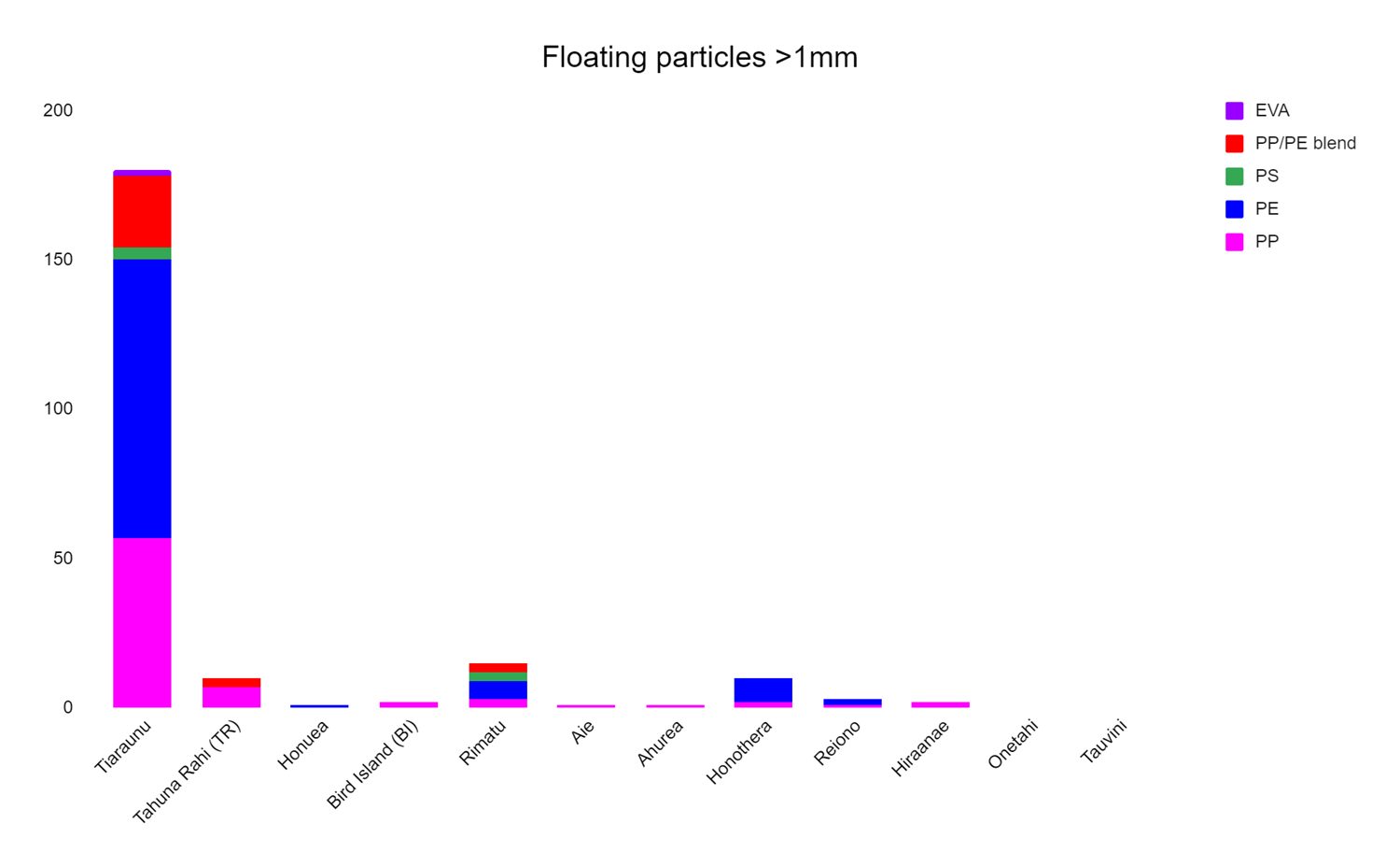
Microplastics in the marine environment: research in Tetiaroa
Transitioning from a SAFS research scientist to a graduate student in Fall 2023, Kat Lasdin is familiar with the world of microplastics research. As a member of Jacqueline Padilla-Gamiño’s lab, one of the projects Kat has been involved in focuses on water, sand, and microplastics in Tetiaroa, an atoll in French Polynesia. Tetiaroa is also the site of a breadth of other UW-led work, including seabirds and shark research.

Kat Lasdin
Visiting Tetiaroa in October 2022, Kat took samples of dry sand, wet sand, and water, looking for the prevalence and abundance of plastics in this remote region of the world. Located 30 miles north of Tahiti, the 4.5 miles of the Tetiaroa atoll is enclosed by a reef with nearly no opening. “This makes it a unique place to conduct microplastics research and ask questions such as what type of plastics are found here, where in the atoll are they, and is there a geographical difference in the prevalence of plastics that we find,” Kat shared.
What’s the difference between plastics and microplastics? Microplastics are classed as anything under 5mm in length, and for her research project, Kat is looking at plastics 1mm and greater. Due to the slow degradation of plastics, they have a high likelihood of being ingested by, and accumulating, in various organisms. They’re also a big factor in ocean pollution around the world.

Kat Lasdin
“So far in my analysis, I’m finding that one spot in particular on Tetiaroa, the northwestern area on the lagoon side, has a lot more plastics than anywhere else we’ve seen on the atoll,” Kat said. Digging into the possible reasons behind this, Kat questions whether it could be due to oceanographic differences, or areas of high accumulation. “I’ll be looking into this further in the upcoming months and during the next trip, as well as setting up another project to watch how plastic degrades in the environment over several years,” she added.

Kat Lasdin
Lot of degradation studies have been conducted on plastics around the world, but Kat and the team she works with have a specific focus on the marine environments in tropical areas such as Tetiaroa and Hawaii, where other work in the Padillo-Gamiño lab is conducted. The idea is to bring plastics to these locations, using their base in Washington State as a control, to investigate how the same type of plastic from the same manufacturer degrades in different parts of the world. “We interact with tropical marine environments most frequently in our lab, and every piece of plastic found in the environment is so different. We’re interested in seeing how the same piece of plastic, over the same timeframe, with the same test parameters, degrades in a different way or the same way, depending on the location,” Kat shared.
With another trip planned for the end of 2024, Kat will conduct exposure studies with organisms and plastics as part of her PhD project.
Click below to enlarge the graphs
-

- The number of 1-mm or greater plastic pieces found per motu that are denser than Milli-Q water. The first density separation occurred in the field with cold saltwater.

-

- The number of 1-mm or greater plastic pieces found per motu that are less dense than Milli-Q water. The first density separation occurred in the field with cold saltwater.
-
- The length of each individual piece collected and verified as plastics from the dry sand in Tetiaroa.

Examining the impact of settler colonialism on Indigenous food systems
Working at the intersection of environmental justice, food sovereignty, and community-based research, Nicole Doran is centering Indigenous perspectives in her work. Nicole’s research for her masters degree, as a member of Mark Scheuerell’s Applied Ecology Lab at SAFS, has involved a deep dive into available literature to examine the impact of settler colonialism on Indigenous food systems.
With this year marking the 50th anniversary of the Boldt Decision, which upheld the rights of members of several Western Washington Indigenous tribes to fish in accordance with terms of treaties signed in the 1850s, discussions around this topic remain deeply relevant.
Nicole’s literature review, comprising her first thesis chapter, delved into historical documents, accounts, academic papers, traditional ecological knowledge, and reports. “I’m presenting a framework for understanding the layers of environmental injustice that permeates cultural food systems such as those maintained by Indigenous communities,” she said.
In order to take a deeper look into how Indigenous thoughts about topics such as food sovereignty and access differ from western science, Nicole highlights an example: “When thinking about contaminants and banning fishing, state or federal regulators may decide that any containment above a certain level means fishing should be banned. Indigenous ways of thinking have a different focus on this issue, where either no level of containment is acceptable, or that a particular fish is so important spiritually and traditionally in the community, that it should still be harvested,” she shared.
Digging into the concepts of food sovereignty and food security, and the big impact of environmental justice on Indigenous food systems, Nicole found that there is a key distinction to be made. “A lot of Indigenous communities lack food security, but for ones who have this, it isn’t enough. Food sovereignty is highly important too,” Nicole said. “Is the food they have access to healthy, traditional, and prepared in a self-governed way? Food sovereignty elements are extremely important, but in the eyes of the government for example, who provide food and other commodities – spam, white flour, sugar, oil – this food security is enough.” The topic of limitations on access to traditional and cultural food also brings to the fore issues around the nutritional value and healthiness of commodities provided, which have led to increases in diabetes and heart disease in these communities. In the food literature that Nicole looked into as part of her second chapter on this topic, she found that food security and food sovereignty weren’t considered together, but they should be.

Nicole Doran
Bringing all of this work together in her third chapter, Nicole explored how to build resilience from an ecology perspective. Indigenous communities recognize that our world is always in flux – climate, food, environment, resources – and it’s an important aspect to consider when thinking about food systems. “The principle of being in a relationship with environments in traditional ways, not separated from nature, but rather tightly interwoven through reciprocal relationships, is incredibly important,” Nicole shared, but this has been significantly affected by settler colonialism.
One of the key takeaways Nicole wants to highlight from her research has been the ways in which people should connect with Indigenous ways of thinking and scholarship: “There are a lot of well-meaning people wanting to connect with Indigenous scholars, but the first step is to engage with the land you work on and look more deeply into how science itself has been impacted by settler colonialism”. Another vital learning that Nicole wants to share is the importance of ethical collaboration. “Bringing back the research to the community, sharing the outcomes, speaking openly, and respecting the relationship of trust that has been developed, is so important, and a lesson worth learning for a lot of people working in this space,” she noted.

Looking ahead: what does climate change have in store for Pacific Coast fish?
From Alaska to California, researchers are looking into the impact of climate change on the distribution of fish that live near the seafloor. Focusing on species such as halibut, pollock, sablefish and rockfishes, which have commercial and environmental importance for the Pacific Coast of the US, these fish are impacted in different ways by shifting ocean temperature and oxygen, resulting in a myriad of knock-on effects.

We spoke with Julia Indivero, a PhD student at SAFS, about what some of these effects could be. Rising temperatures and decreasing oxygen may affect where fish can live, which in turn may change how close they are to boats and ports involved in the fishing industry. “Fishers are used to fish being in a certain area, and if fish move farther away, this may become difficult for fishery operations. Different species responses to ocean conditions may also change the overlap in habitat between species and impact possible bycatch issues,” Julia shared.
Julia’s research is combining data to look at the Pacific Coast in its entirety, versus being separated out by region as is usually done in work on this topic. By combining predictions for multiple regions, researchers can build models which include more sensitivities and reflect broader-scale change in fish distribution.
Conducting her work in Tim Essington’s Marine Conservation and Ecology Group, Julia’s quantitative research involves developing models to predict where fish may be located under future climate change scenarios. By combining data on ocean conditions and on fish abundance from thousands of locations each year from the 1990s through 2023, these models estimate how fish abundances are impacted by temperature and oxygen. Then, these relationships are used to predict fish abundances at these locations if temperature and oxygen change, following what global forecasts of human-caused carbon emissions expect.
Countries and fishery management bodies around the globe are interested in understanding how fish distributions might shift in future climates.
“The possible implications for transboundary governance is especially interesting. Quotas, catch limits, treaties, and protected areas, are all based on geographic locations, but fish ignore these boundaries when big climate change shifts happen,” Julia said.
This makes the ability to predict future fish distributions even more important, so that individuals, regions, and countries, can better anticipate these changes and put in place the required modifications to management structures and boundaries now.
There is an inherent level of uncertainty when making forecasts based on climate change shifts in ocean temperature and oxygen. The models that Julia works on recognize these uncertainties: “There’s uncertainty in the level of carbon emissions that will happen, there’s uncertainty in the exact temperature and oxygen change in the ocean, there’s uncertainty in how fish will respond to a changing environment. But predictions can provide us with plausible scenarios and a range of possible future situations.” One area that needs some work, Julia mentions, is understanding how relationships between fish and ocean conditions that are based on data from the past, may hold up or break down in a warmer world: “We’re developing methods to try to better predict how fish might respond to temperature and oxygen levels that are completely beyond what they’ve experienced before.”
What would pre-emptive action to deal with future changes in fishery distribution look like for those on the ground?
“Fishers could look at these predictions and start investing in different types of vessels and gear needed to catch new fish in their fishing areas,” Julia said. “Being able to share scientific information that informs diversification efforts would be a great benefit,” she added.
On a large scale, ports and cities can start investing in infrastructure that has the ability to process different fish products based on future predictions. Managers can begin developing flexible policies that allow individual vessels and fishers to switch permits between species. It also reaches the highest level of those involved in fisheries management. “At an international level, future predictions of fish distribution mean they can start thinking about how to deal with, and adapt, to species moving in and out of national boundaries,” Julia shared.
Now in her fourth year at SAFS and just getting started on this research, Julia will be focusing on this topic for the remainder of her PhD.
Will the tides change on tidal energy in the US? Quantifying fish encounters with tidal turbines
Diving into the world of marine renewable energy, Jezella Peraza, a masters student at SAFS, has recently published a paper looking into the probabilities of fish-turbine encounters and impact.
Whereas the renewable energy sector utilizing solar and wind energy is booming in the United States, the uptake of tidal energy is off to a slower start. Tidal turbines, placed on the sea floor, generate energy when water moves through a constricted area.
“We want to understand the environmental impacts tidal energy might have on marine ecosystems and organisms before utilizing this energy source. The US won’t allow the permitting and consenting process to occur before having data on potential encounters and interactions between tidal turbines and underwater life,” Jezella shared. This approach is flipped in Europe, who have taken the approach of monitoring impacts on the ecosystem while marine renewable energy projects are underway.
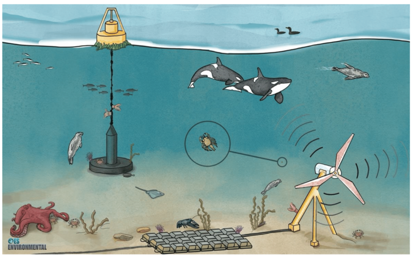
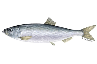
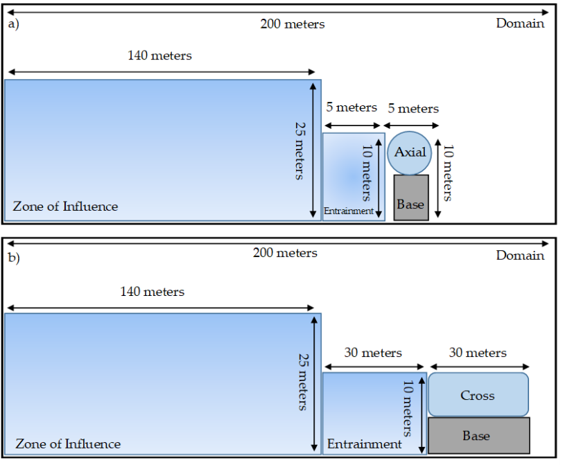
Using empirical statistical and simulation models, Jezella set out to estimate interactions between fish, specifically Pacific herring, and tidal turbine devices. She also took this a step further to address knowledge gaps when quantifying risks, by also exploring fish behavior before they encounter the turbine directly. In her literature review, she noted fish actively avoid a tidal turbine around 140m away, where they notice something unusual in the distance and then change their trajectory to avoid it. “This so-called zone of influence, which is within 140m of the turbine, is important to explore because it gives us insight into general fish avoidance behavior,” Jezella said.
NOAA Fisheries
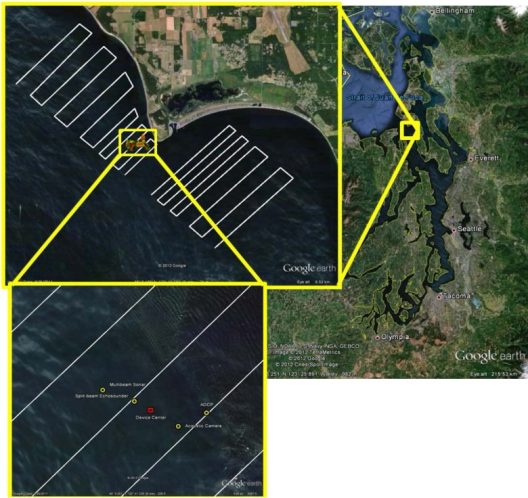
By analyzing existing literature and models, Jezella investigated what was missing and drafted a comprehensive model with her advisor, John Horne, that contains everything they think is important to include when estimating fish-turbine interaction probabilities. To fit their model, named the Probabilistic Encounter-Impact Model, they used fish density survey data from Admiralty Inlet, Washington, which is a proposed tidal energy project site, plus literature parameter values. This has allowed them to ascertain probabilities for each component of the model:
- What is the probability of fish being in the zone of influence? This is when fish are 140m away from the turbine.
- What is the probability of fish encountering the turbine? This would involve being within 10s of meters of the turbine.
- What is the probability of impact? This involves collision with stationary turbine structures or an interaction with turbine blades.
What did Jezella find out using her model? One of the key insights was that avoidance behavior has a big influence on probabilities of impact, and this is the kind of information that regulators and managers are interested in when considering future permitting of tidal turbines. Specifically, she found that when avoidance was not applied to her model, impact probabilities were two to three orders of magnitude greater than when avoidance is incorporated. Information on avoidance behavior is hard to come by however. “There is limited data on this, so researchers in the past have used controlled experiments in the field or in the lab, where they observe what fish do around tidal devices. And in most cases, fish will avoid it,” Jezella said. “However, this isn’t truly a real-life situation as it’s still an experiment,” she added. Other studies have used cameras to observe fish avoidance and have noted that they go through the blades, or up and over the turbine. But what happens in a scenario where flow speed is really high, and they get sucked in?
The second chapter of Jezella’s thesis project will take her work forward and consist of an agent-based model, where the model acts as a flexible simulation tool that takes into account types of behaviors and environmental factors, such as tidal flow. This would provide a real-time look into fish swimming in the area of the tidal turbine and see what they do: do they take action to avoid the device, or do they interact with it? It is also designed to be applicable for other underwater life such as marine mammals. Another area of flexibility in the model is in the type of tidal turbine investigated. Tidal turbines range from cross-flow and axial flow, and come in a variety of sizes stretching from 5m in width to 30m in width.

When making her decision to apply for a masters program, Jezella wanted to build on the quantitative skills she developed during her Statistics Minor as an undergrad, and also to work on a unique project where she could make an impact. Her thesis project on the probabilities of fish encounters with tidal turbines ticked all the right boxes: “Working on a project related to climate change and possible mitigation is something worthwhile to me. Taking the measures to protect fish and marine mammals if marine renewable energy does take off in the US in the future is really exciting, as it’s currently an untapped resource with a lot of sustainability potential.”
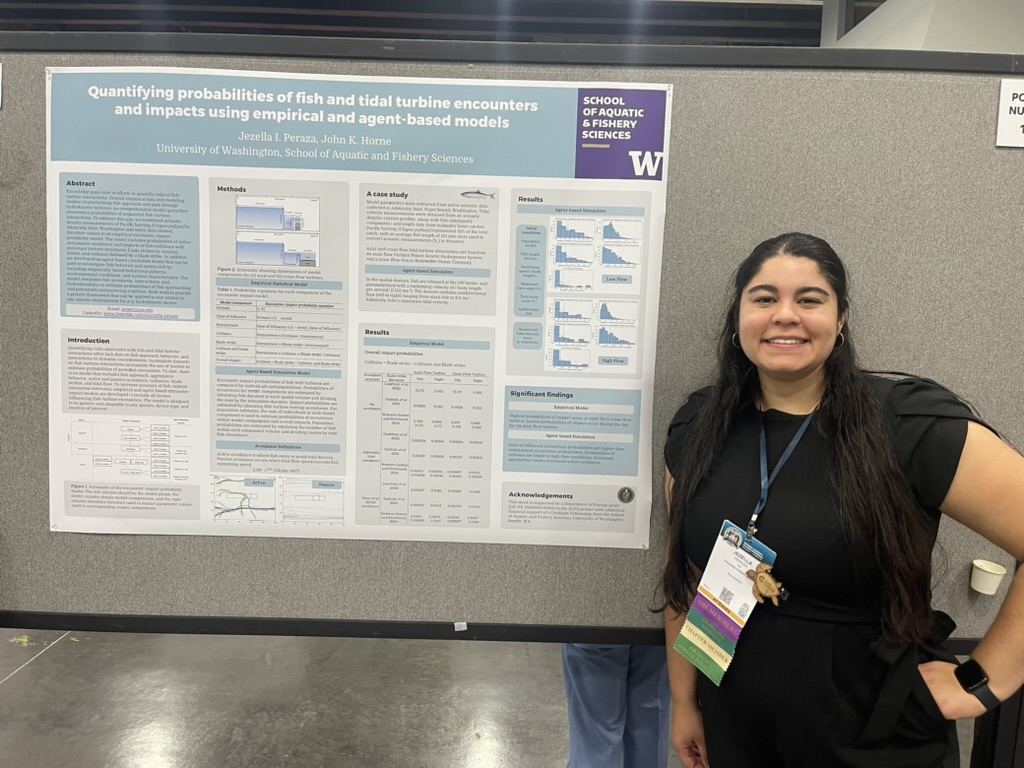
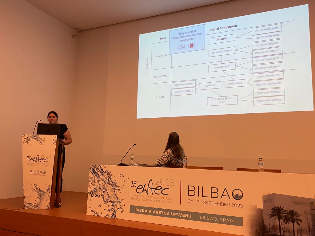
Jezella has presented her research at a number of conferences in the past year, including an oral presentation at the European Wave and Tidal Energy Conference (EWTEC) in Bilbao, Spain, the University Marine Energy Research Community conference in Durham, New Hampshire, and SACNAS in Portland, Oregon.
-

- Jezella presenting her poster at SACNAS 2023.
-

- Jezella giving a presentation at EWTEC.
A view from above: using drones for coastal research in California
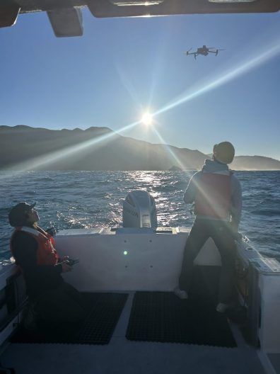
Newly based at the University of Washington is the Marine Landscape Ecology Lab (MLEL), led by SAFS Professor, Corey Garza. Conducting research along the Californian coast using drones, Corey’s lab is currently working on two projects funded by the California Ocean Protection Council.
In a collaborative effort with UC Santa Cruz, Stanford University, and the Middlebury Institute for International Studies, the team is trying to understand how the interaction between oceanographic conditions and the presence of marine mammals, impacts the presence of great white sharks.

Michael Espriella
Precipitated by recent great white shark attacks on humans in the Monterey area, California is exploring ways to try and avoid this by exploring the conditions which increase the likelihood of great white sharks being closer to shore.
Using drones to map the central California coast and the presence of pinnipeds such as sea lions, fur seals, and elephant seals, all of which are prey for great whites, the MLEL team is helping deliver new insights into what factors increase great white shark presence. As prey species stick closer to the shore, this leads sharks closer to the coast. In turn, this raises the frequency of interactions with humans who are in coastal waters, swimming, surfing, and diving.

Corey Garza/MLEL
Another factor at play is oceanographic conditions and how it impacts pinnipeds. Data has shown that pinnipeds are more commonly present onshore in April, and the team is working to get more information on monthly variation, plus improve understanding about what factors cause pinnipeds to aggregate in different coastal locations. El Niño and La Niña-related driven changes in coastal conditions may alter the abundance and distribution of prey commonly preferred by pinnipeds. This can result in pinnipeds seeking out coastal areas where their preferred prey are abundant.
With the overarching aim of public education, the institutions involved are researching a number of aspects:
- The MLEL carries out drone mapping of the coastline to record variation in pinniped abundance.
- UC Santa Cruz is mapping and track pinnipeds to see where they are diving and swimming.
- Stanford is tagging sharks and using telemetry to see where they’re going and utilizing oceanographic instrumentation to monitor changes in the coastal environment.
- The Middlebury Institute for International Studies is developing educational materials to support public outreach.
How does research fit into a public education and awareness campaign? By providing the scientific information behind California’s efforts to make local people and tourists more knowledgeable about what conditions and times of year result in a higher frequency of great white sharks.

Michael Espriella
A second project underway with Corey and his MLEL team is developing high-resolution digital elevation models (DEMs) of the rocky intertidal, also known as the rockpool area, along the entire California coastline from San Diego to Humboldt County. Building on biological monitoring data collected the Multi-Agency Rocky Intertidal Network (MARINe), a collaborative monitoring program led by UC Santa Cruz since the mid-1990s, this project will integrate MARINEe’s long-term monitoring data with digital elevation models.

Corey Garza/MLEL
Using drones to map the topography of the intertidal mussel beds across 100 sites, the team will use the topography data collected by the drones to create DEMs. These DEMs will be used to support modeling to predict how sea level rise may change the future distribution and composition of rocky intertidal communities in California.
Barbara Block
The rocky intertidal is the frontline when it comes to climate change and associated rising sea levels. It’s also an incredibly important ecosystem from both a habitat and economic point of view. On the habitat side, the rocky intertidal is a site home to keystone species that help maintain biodiversity for the entire ecosystem, as uncovered by Robert (Bob) Paine’s foundational ecology work with ochre sea stars and mussels.
From an economic standpoint, this part of the Californian rocky intertidal is home to black and red abalone, recreational fish nurseries, and mussel beds, which are an important foraging habitat for the Pacific spiny lobster, just to name a few.
Heading out once a month to conduct drone research for both projects, the MLEL team consists of four members including Corey: graduate student Olivia Bible, post-doc Michael Espriella, and technician, Jason Ching.
Interested in related work? Check out Eos’ article with Corey Garza about tracking ocean warming and its impact on California’s mussel beds using time-series photos.
![]()
Taking a deeper look: using fish eye lenses to explore invasive fish impacts on native fish communities
Fighting for the little guy. That’s one of the things Jess Diallo, PhD candidate at SAFS, likes about her work. Her research encapsulates this idea as she explores the impact of invasive fish on native fish food webs, based in a tributary to the lower Colorado River.
Part of Julian Olden’s Freshwater Ecology and Conservation Lab, Jess’ fieldwork in 2021 involved collecting samples for stable isotope analysis, including fish eye lenses, to provide a deeper look into how fish move throughout the food web.
“The two main characters in this story are roundtail chub, a native fish, and green sunfish, an invasive species,” Jess shared. “It’s important to study the impact of invasive species on native populations as the whole ecosystem can be impacted by the predation and competition threat that they pose,” she added.

Jess Diallo
The invasive fish living in her study site, the Burro Creek basin of the Bill Williams River, a tributary of the lower Colorado River, consist of species introduced throughout the last century, which are now the focus of sport fishing, including bullhead and green sunfish. Native species in this system include roundtail chub, desert sucker and Sonora sucker.
“Using fish eye lenses to conduct stable isotope analysis is a really cool method,” Jess said. “The eye lens grows in concentric spherical layers, building on itself over time. And when you dissect this tissue, you can look through time into how the fish moved through the food web.”
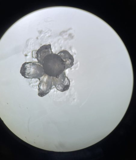
Jess Diallo
This method allows Jess to see clear shifts in diet throughout an individual’s life, for example from a juvenile fish eating insects, to growing larger and graduating up to eating other fish. Food consumption provides a clear signature in stable isotope analysis, and Jess is interested in exploring how invasive and native fish interact in the food web throughout their lifetime, and the comparison with native fish-only communities.
Studying five species of fish in total, Jess has seen some clear results from the stable isotope data she has collected. “The lifetime trophic trajectories of native fish species are, on average, displaced within the food web when they’re in streams containing invasive species, compared to native-only communities,” Jess shared.
This displacement is seen in lower values of Carbon-13 and Nitrogen-15, meaning a dietary shift from terrestrial to aquatic plant carbon sources and a lower position on the food chain.

Beka Stiling
Sharing why some streams are inhabited by native-only fish and others have the presence of invasive species, Jess noted that it’s down to the hydrology and climate of the area: “Burro Creek has intermittent streams that flow when there’s rainfall, but become isolated pools during the dry season. This fragmented system means that when invasive fish were introduced in a reservoir on the lower Bill Williams River, their progress upstream was slowed by dry stream sections.”
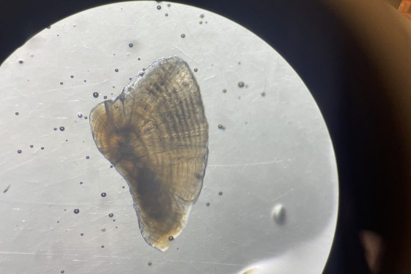
Another area of Jess’ work is using otoliths, the ear stones of fish which can be used to age them, to link the chronological record of stable isotope values to time. “These two parts of a fish, their eye lenses and their otoliths, are two records of a fish’s lifetime. This is really novel research, linking the otoliths to eye lenses, especially for community ecology, so it’s really exciting work to be involved in,” she said.

Jess Diallo
Jess wants to be able to take all of the individual fish and different species present in the river and put them all on the same timescale. “This is where both methods come in. The fragile, crystalline structure of fish eye lenses mean you can only measure the size of each layer as it’s peeled back, a bit like an onion. These measurements are proportional to fish body size,” she shared. “By using otolith data too, we hope to be able to go from fish body size to fish age and shed insight into the impact of things like season and hydrology on the food web”.
Jess Diallo
“This work has really highlighted for me the beauty in the tiny things – fish eye lenses, otoliths – and the wealth of information they hold,” Jess said about her research. It has also been an important learning experience when conducting science. Not only did Jess conduct her research in an area facing a myriad of different factors such as water extraction and different land use issues between private and government entities, adding in fish conservation presented a new optic.
“My research was also a steep learning curve and I hope to be able to share new methods and best practices in the future,” Jess said. “This type of research combining stable isotope data from fish eye lenses with otoliths hasn’t been done before, and trying to figure out the best way to peel an eye lens or polish a lapillar otolith taught me an awful lot about these species.” Dissecting at least 400 fish and working on between 1-15 tissue samples from each one, Jess hopes to contribute her learnings through a methods paper to other researchers in the fish ecology field.
Arial Brewer speaks with OPB about the impact of ship noise on beluga whales
SAFS PhD student, Arial Brewer, joins the Oregon Public Broadcasting ‘Think Out Loud’ series to share her research into the impact of ship noise on Alaska’s Cook Inlet beluga whales.
Special issue on Building Diversity, Equity, and Inclusion in Ocean Sciences features SAFS scientists
With contributions from SAFS scientists including Jackie Padilla-Gamiño, Corey Garza and Xochitl Clare, Oceanography’s special issue addresses structural and cultural obstacles encountered by underrepresented and marginalized scholars.